")
United Kingdom Map (National Geographic Adventure Map, 3325)
$14.95


Price: $14.95
(as of Jan 04, 2024 13:50:05 UTC – Details)
• Waterproof • Tear-Resistant • Travel Map
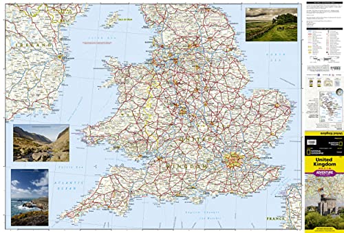
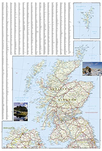
National Geographic’s United Kingdom Adventure Map is designed to meet the needs of adventure travelers with its detailed, accurate information and user-friendly design. Cities and towns are easy to find with the map’s helpful index. Motorways, highways, and other roads are clearly designated and include distance in kilometers so travelers can easily plan their best route. With specialty content to include hundreds of diverse and unique recreational, ecological, cultural, and historical destinations, this map is a perfect companion to a guidebook.
The south side of this map covers the southern portion of the UK, from the tip of France and across the Isle of Man to Northern Ireland. The north side shows Belfast, and across the Channel to Edinburgh, the Outer Hebrides, the Orkney Islands, and the Shetland Islands.
The United Kingdom is comprised of the island of Great Britain which includes England, Wales, and Scotland; surrounding islands including the Outer Hebrides, Orkney Islands, and Shetland Islands; and Northern Ireland. No part of the UK is more than 75 miles from the sea, but the geography is diverse. England consists of mostly lowland terrain with mountainous regions found in the north and in Wales. Scotland is divided into two distinct regions by the Highland Boundary Fault which separates the Highlands to the north and west and the lowlands in the south and east. The largest body of water in the UK is Northern Ireland’s Lough Neagh. Though it is the largest body of water by surface area, Scotland’s Loch Ness is larger by volume due to its great depth.
Every Adventure Map is printed on durable synthetic paper, making them waterproof, tear-resistant and tough — capable of withstanding the rigors of international travel.
Map Scale = 1:825,000Sheet Size = 37.75″ x 25.5″Folded Size = 4.25″ x 9.25″
From the Publisher


National Geographic’s Adventure Maps — Essential travel tools for destinations across the globe
With over 100 available titles, these detailed travel maps are the perfect companion for the trip of a lifetime. Sometimes an accurate, tough, waterproof map is the best travel tool you can carry. In areas without cell coverage, or when the data plan is running low, a National Geographic Adventure Map will quickly become an essential travel tool. Featuring detailed road networks, key points of interest, UNESCO World Heritage sites, a place name index, and beautifully rendered shaded relief these travel maps are perfect for pre-trip planning and on the ground navigation.
Perfect for Domestic or International Travel Waterproof Tear-Resistant Nearly Indestructible Clean Cartographic Design for Easy Navigation
Number of International Visitors
1.3 million 3.0 million 32.6 million 2.6 million 3.4 million
Official Language
Icelandic English and Māori Thai Spanish Spanish
Unit of Currency
Icelandic Króna New Zealand Dollar Thai Baht Costa Rican Colón Sol


Your Purchase Has Purpose
Every purchase helps support the National Geographic Society, an impact driven, nonprofit organization with global reach that uses the power of science, exploration, education, and storytelling to illuminate and protect the wonder of our world.
Publisher : National Geographic Maps; 2022nd edition (January 1, 2022)
Language : English
Map : 2 pages
ISBN-10 : 1566956447
ISBN-13 : 978-1566956444
Item Weight : 3.21 ounces
Dimensions : 4.25 x 0.16 x 9.25 inches


There are no reviews yet.