")
Guatemala Map (National Geographic Adventure Map, 3110)
$14.95


Price: $14.95
(as of Apr 13, 2024 18:06:56 UTC – Details)
• Waterproof • Tear-Resistant • Travel Map
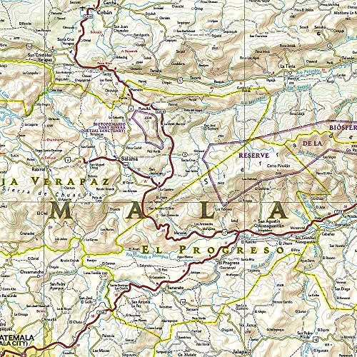
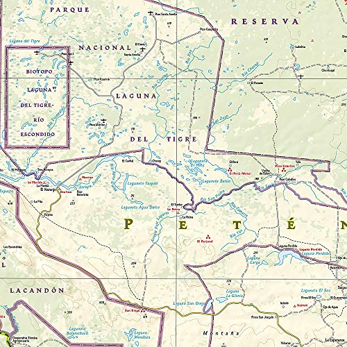
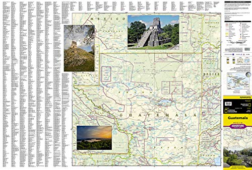
National Geographic’s Guatemala Adventure Map is the most comprehensive map available for travelers exploring the country’s rich cultural heritage and diverse natural beauty. Combining a clearly marked road network, a user-friendly index of cities and towns, topographic information and points of interest, this expertly researched map is the perfect companion to any guide book. The mapped road network, shown with distances, includes major highways and secondary roads along with high clearance roads and tracks, for those seeking to explore off the beaten path. Additional travel information includes airports, airstrips, ferry routes, railroads and border crossings. Among the hundreds of pinpointed cultural, ecological, historical and adventure destinations are national parks and other protected areas, archeological sites, caves, beaches, shipwrecks, coral reefs, UNESCO World Heritage Sites.
The front side covers northern Guatemala and its northern border regions with Mexico and Belize. Included are the Mayan areas of El Mirador and Tikal National Park along with the island town of Flores on Lake Peten Itza. The reverse side covers the country south of the Yucatan Peninsula, bordering areas of Mexico, Honduras, El Salvador and Belize, the Pacific Ocean shoreline and part of the Gulf of Honduras. In this area you’ll find the World Heritage site of Antigua, Lakes Atitlan and Izabel, Pacaya Volcano and the capital, Guatemala City.
Every Adventure Map is printed on durable synthetic paper, making them waterproof, tear-resistant and tough — capable of withstanding the rigors of international travel.
Map Scale = 1:500,000Sheet Size = 37.75″ x 25.5″Folded Size = 4.25″ x 9.25″
From the Publisher


National Geographic’s Adventure Maps — Essential travel tools for destinations across the globe
With over 100 available titles, these detailed travel maps are the perfect companion for the trip of a lifetime. Sometimes an accurate, tough, waterproof map is the best travel tool you can carry. In areas without cell coverage, or when the data plan is running low, a National Geographic Adventure Map will quickly become an essential travel tool. Featuring detailed road networks, key points of interest, UNESCO World Heritage sites, a place name index, and beautifully rendered shaded relief these travel maps are perfect for pre-trip planning and on the ground navigation.
Perfect for Domestic or International Travel Waterproof Tear-Resistant Nearly Indestructible Clean Cartographic Design for Easy Navigation
Add to Cart
Add to Cart
Add to Cart
Add to Cart
Add to Cart
Customer Reviews
4.6 out of 5 stars
1,177
4.7 out of 5 stars
571
4.5 out of 5 stars
160
4.7 out of 5 stars
849
4.6 out of 5 stars
238
Price
$13.31$13.31
$12.60$12.60
$12.60$12.60
$13.46$13.46
$12.60$12.60
Number of International Visitors
1.3 million 3.0 million 32.6 million 2.6 million 3.4 million
Official Language
Icelandic English and Māori Thai Spanish Spanish
Unit of Currency
Icelandic Króna New Zealand Dollar Thai Baht Costa Rican Colón Sol


Your Purchase Has Purpose
Every purchase helps support the National Geographic Society, an impact driven, nonprofit organization with global reach that uses the power of science, exploration, education, and storytelling to illuminate and protect the wonder of our world.
Publisher : Natl Geographic Society Maps; 2022nd edition (January 1, 2022)
Language : English
Map : 2 pages
ISBN-10 : 1566956544
ISBN-13 : 978-1566956543
Item Weight : 3.21 ounces
Dimensions : 4.25 x 0.2 x 9.25 inches


![National Parks Scratch Off Map of United States Poster [ALL 63 Parks] INCLUDES Wildlife, US Travel Map Print, USA Gift for Travelers Road Trip Adventure Journal, Fits 16”x20” frame by Bright Standards](https://m.media-amazon.com/images/I/51T6dY1D6rL._AC_.jpg)


There are no reviews yet.